Chica – February 25, 2013 – June 20, 2019
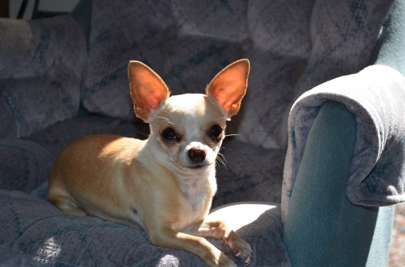 On June 20, 2019 I had to say goodbye to my precious Chica. She was the love of my life for over 6 years. She found me in Mesa, AZ in February 25, 2013 and we were together until June 20, 2019 when I had to senT her to Doggie Heaven.
There were only a few days when we were ever apart. When I traveled to Ireland, England, Scotland and Wales as well as a few trips to visit family in SO CA. We traveled all of the West in our RV. I showed her many of the wonders of Arizona, New Mexico, Colorado, Utah, Wyoming, Idaho, Montana, Nevada, California, Oregon, Washington. We even traveled as far into Canada as Jasper.
She loved traveling in the RV and whenever we were driving she was always right on my lap. We went to places that were as warm as 115 degrees and as cold as -4 degrees. She didn’t care where she was as long as she was with me.
Every summer we spent 4 months at Lake Harriet, OR where I was the camp host. This was our fifth summer there. Sh loved it there and would never stray out of my campsite. She would lay in the sun and drink beer with me. I can’t remember when it started but when I would take a swig out of the bottle, she in turn would lick the inside and get a taste of the beer. This went on for many years. It got to be that if I took two swigs in a row without sharing it with her she would definitely let me know. That is true friendship.
Most of the time she never wore a collar and she would always stay right with me all of the time. She was a great companion!!!!!
In 2017 she had surgery on both her back kneecaps, which had come out of the sockets. From that point on I had to lift her up and down on the couch. This past winter, she would wake up in the middle of the night with anxiety attacks and would want to get up on the couch and then get down immediately. This would go on for about an hour. I took her to our vet and she noticed that her front leg was not right. She mentioned that this was a Neurology problem and recommended a specialist. I took her to the specialist and she thought that she might have a neck problem which caused the leg problem. However she quoted a price which was insurmountable. It would take almost all the earnings I made during the summer and then she couldn’t reassure me that it could also be Cancer. She was drawing blood from her for a test and she said her tongue turned purple, which is not normal. I took her to my regular vet and had her do a chest X-ray. Before she did the chest X-ray, she mentioned that she had a heart murmur. She showed me the chest X-ray and it showed that she had an enlarged heart. She probably had an enlarged heart due to loving me so much.
Then her leg began to get worse. It got so she could not put any weight on it without falling over. She could not pee or poop either as she would fall over. Plus she always had her tail between her legs, which was not like Chica. I decided that she had suffered enough and after loving and petting her for hours that night took her into the vet. I think she must have known I was helping her as she was calm the whole time she was in the vet, which was not normal for her.
I will always love my Chica and always used to call her “My Little “GURL”. I asked the vet for her ashes and I will bury them this spring with a beautiful yellow rose dedicated to her and our love.
I LOVE YOU CHICA !!!